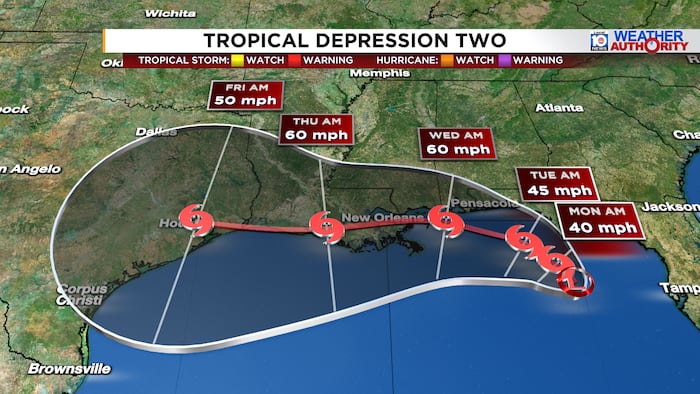
A new tropical system has developed in the northern Gulf of Mexico, prompting weather officials to issue warnings for residents along Florida’s panhandle. The National Hurricane Center began issuing advisories on July 19, 2026, for Tropical Depression Two, which is expected to intensify in the coming hours and could become a named tropical storm by the evening or early next week.
Current Status and Movement of the Storm
The tropical depression is currently crawling toward the north-northwest at approximately two miles per hour, a notably slow pace that could allow the system to strengthen as it lingers over the warm Gulf waters. Forecasters anticipate the depression will maintain this slow northwestward or north-northwestward motion over the next day or two before eventually turning toward the west.
According to the latest observations from the National Hurricane Center, the system is producing maximum sustained winds of approximately 30 miles per hour, with occasional higher gusts. The minimum central pressure has been measured at 1011 millibars based on surface observations. These conditions indicate a relatively weak system at present, but meteorologists are closely monitoring its development.
“Gradual strengthening is forecast, and the depression is expected to become a tropical storm tonight or on Monday,” the National Hurricane Center stated in its official advisory.
Watches and Warnings in Effect
In response to the developing threat, authorities have issued a Tropical Storm Watch for a significant stretch of the Florida coastline. The watch extends from the Ochlockonee River westward to the Alabama border, encompassing communities throughout the Florida panhandle that could experience tropical storm conditions within the next 48 hours.
Residents in the affected areas are strongly encouraged to take the following precautions:
- Review and update emergency supply kits with essential items including water, non-perishable food, medications, and batteries
- Secure outdoor furniture, decorations, and any loose items that could become projectiles in strong winds
- Ensure vehicles have adequate fuel in case evacuation becomes necessary
- Stay informed through official weather channels and local emergency management communications
- Know your evacuation zone and have a plan in place for where you would go if ordered to leave
- Check on elderly neighbors and family members who may need assistance preparing
Projected Path and Potential Impacts
Based on the current forecast track, the depression is expected to move near or along the northern Gulf coast over the next several days. This prolonged interaction with coastal areas could bring persistent rainfall, gusty winds, and elevated surf conditions to communities from the Florida panhandle westward along the Gulf coast.
The slow movement of this system is particularly concerning to meteorologists, as tropical systems that linger over an area tend to produce more significant rainfall totals than those that move through quickly. Flooding could become a concern for low-lying areas and locations prone to poor drainage, especially if the system stalls or meanders along the coast.
While Miami and South Florida are not currently in the direct path of this system, residents throughout the state should remain aware of developments, as tropical systems can be unpredictable. The formation of Tropical Depression Two also serves as an important reminder that the Atlantic hurricane season is well underway, and all Floridians should have their hurricane preparedness plans ready to implement at a moment’s notice.
The National Hurricane Center will continue to issue regular updates on Tropical Depression Two as the situation evolves. Residents in the watch area should monitor these advisories closely and be prepared to take action if warnings are issued or conditions deteriorate. Local emergency management officials will provide guidance specific to individual communities as needed in the coming days.