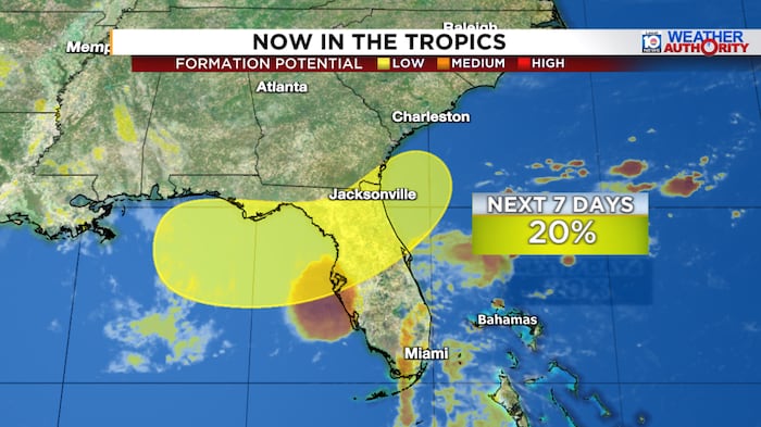
Florida residents along the state’s western coastline should prepare for a wet weekend as meteorologists track a weather system in the Gulf of Mexico that could bring significant rainfall starting on July 19, 2026. The National Hurricane Center is closely monitoring an elongated corridor of low pressure that stretches down the southeastern United States coast and extends into the northeastern Gulf, with particular attention to the area near Florida’s Big Bend region.
Tropical Development Remains Unlikely Despite Warm Waters
While the system has caught the attention of weather experts, the chances of it developing into a named tropical system remain relatively low. The disturbance faces several challenging environmental conditions that make significant organization difficult. Its proximity to land and interaction with coastal areas, combined with moderate to strong wind shear in the surrounding atmosphere, create obstacles for tropical development.
However, meteorologists are quick to point out that the situation warrants continued monitoring. The northeastern Gulf of Mexico and waters off the southeastern coast are experiencing near-record warm temperatures for this time of year, creating conditions that could potentially support the brief formation of a weak tropical depression or low-end tropical storm.
The challenging environmental conditions and disorganized starting place of the disturbance don’t support significant organization, but a weak, short-lived tropical depression or low-end tropical storm cannot be ruled out given the exceptionally warm Gulf waters.
Heavy Rainfall Expected Regardless of Development
Whether or not the system achieves tropical status, Florida residents should prepare for substantial rainfall. The primary concern extends from Florida’s Sun Coast, including the Tampa Bay metropolitan area, through the Nature Coast, and across the Big Bend region. Heavy rains are expected to begin in earnest on July 19, 2026, with the most significant precipitation expected from July 20 through July 22, 2026.
The affected areas include:
- Tampa Bay metropolitan area and surrounding communities
- Florida’s Sun Coast region
- The Nature Coast along the Gulf
- Big Bend region of Florida
- Interior portions of central Florida
- Northeast Florida, including the Jacksonville area
While overall rainfall totals appear manageable and could actually benefit areas of the state experiencing ongoing drought conditions, the potential for localized flash flooding remains a concern. These tropically-influenced weather patterns can produce extremely high rain rates, sometimes exceeding three inches per hour, which can overwhelm drainage systems particularly in urban environments like Tampa and Jacksonville.
Atlantic Basin Remains Quiet for Now
Beyond this Gulf system, the broader Atlantic basin continues to show relatively quiet conditions heading into the final weeks of July 2026. A robust tropical disturbance in the far eastern Atlantic, located just west of Africa, is also being monitored but is not expected to develop into anything significant. This provides some relief for coastal communities as we move through the heart of hurricane season.
Critical Hurricane Tracking Satellite Back Online
In positive news for weather monitoring capabilities, NOAA successfully restored its GOES-19 weather satellite to full operation on July 17, 2026, following an extended outage. The malfunction, which was traced to software issues aboard the satellite platform, required engineers to reboot the system and place it in a protective safehold mode for approximately 24 hours.
The GOES-19 satellite plays a crucial role in weather monitoring, serving as NOAA’s primary observation platform for the United States East Coast and the tropical Atlantic region. Its restoration is particularly important during hurricane season when accurate and continuous monitoring can mean the difference between timely warnings and dangerous surprises for coastal communities.
This satellite operates separately from the defense-operated, polar-orbiting constellation of hurricane-monitoring satellites that faced potential early termination during the previous hurricane season. Those satellites continue to function normally following a last-minute fix implemented in July 2025 that addressed cybersecurity concerns and kept the vital observation platforms operational.
Florida residents in potentially affected areas should take this opportunity to review their emergency preparedness plans and ensure they have adequate supplies on hand. While this system is not expected to pose a major threat, the heavy rainfall forecast serves as an important reminder that summer weather in Florida can change rapidly and preparation is always worthwhile.